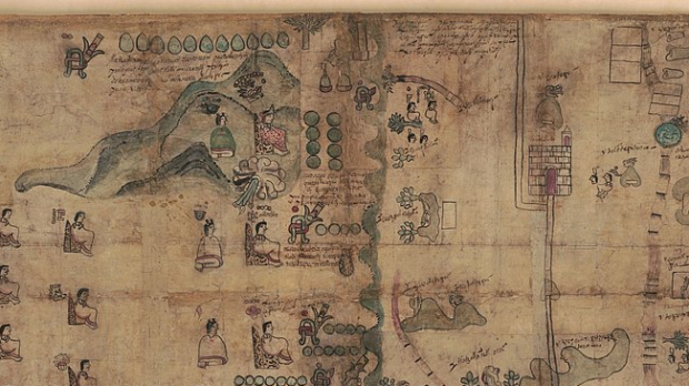
The Codex Quetzalecatzin, also known as the Mapa de Ecatepec-Huitziltepec, the Codex Ehecatepec and Huitziltepec, or the Charles Ratton Codex, is an extra-rare example of a pre-1600 indigenous American codex. This historic piece of art maps the area from just south of modern day Mexico city to Puebla, roughly 80 square miles. The Library of Congress acquired the codex from French collectors and has now digitized it for public viewing online.
John Hessler, archaeologist and curator at the Library of Congress, explains that the purpose of the Codex Quetzalecatzin is to show the extent of land holdings and properties held by the “de Leon” family, as well as tracing their bloodline.
The work is dated to between 1570 and 1595, making it one of fewer than 100 such codices from before 1600. It was created during a time when cartographic histories were being produced both by the Spanish, in order to account for the human and community resources of the indigenous people, by indigenous scribes themselves, in order to reassert their ancient claims to lands seized by the Spanish.
In a description of the Codex, Hessler writes:
It depicts a local community at an important point in their history. On the one hand, the map is a traditional Aztec cartographic history with its composition and design showing Nahuatl hieroglyphics, and typical illustrations. On the other hand, it also shows churches, some Spanish place names, and other images suggesting a community adapting to Spanish rule. Maps and manuscripts of this kind would typically chart the community’s territory using hieroglyphic toponyms, with the community’s own place-name lying at or near the center. The present codex shows the [Spanish] de Leon family presiding over a large region of territory that extends from slightly north of Mexico City, to just south of Puebla. Codices such as these are critical primary source documents, and for scholars looking into history and ethnography during the earliest periods of contact between Europe and the peoples of the Americas, they give important clues into how these very different cultures became integrated and adapted to each others presence.
The form and color of the work reflects the style throughout the Mesoamerican art of this era. Indigenous scribes used naturally extracted pigments to create Maya Blue and cochineal.
The Codex Quetzalecatzin exhibits the indigenous symbols for rivers, roads and pathways, and of course hieroglyphic writing. However, the presence of the Latin alphabet suggests that it was meant to be seen by the Spanish as well. The Spanish titles next to images in the genealogy provide evidence that at least some indigenous elites were granted the Spanish title of nobility (“don”) and had been baptized with Christian names.
You can examine the digital copy of this document at the Library of Congress’ website.

